Pisaq
Today P'isaq constitutes one of the most important Archaeological Parks in the region. It is located about 30 Kms. (18.6 miles) toward the northwest of Qosqo City. Possibly its name comes from a type of partridge very common in the area known as "p'isaqa". Some scholars suggest that the pre-Hispanic City had the shape of a "p'isaqa" (-ornate tinamou- Nothoprocta ornata); a tinamidae that represented the local fauna.
Today, there is also a colonial town named P'isaq in the lower part of the valley, established as consequence of the famous "Indians Reductions" by which the Quechuas were joined in small towns. The Inkan City is on the upper side of the mountain, over the well preserved terracing. It was classical among the Inkas that the most fertile zones must have been reserved for agriculture without being wasted for building towns or cities. Therefore, the city was built taking advantage of the dry and rocky mountain; even more, its location enabled its protection because this was a fortified city on the way to the Antisuyo (Amazonian Jungle). Historians suggest that it was established over there in order to protect the great capital from possible attacks of the Antis nations (the name of the "Andes" Mountains derives from "Anti") that were their worst and never "submitted to" enemy. Today it is still possible to observe the surrounding wall that protected the most important zone of the city. More over, inside the protected area are the vast farming terraces that supplied enough food for its inhabitants in case of sieges or prolonged wars; and there are also aqueducts that supplied water for agricultural development. It seems that water for consumption of the inhabitants was harnessed on the mountain's upper side and transported through underground channels.
There are two possibilities in order to get to the archaeological site from the colonial town: Hike, taking the street on the western side of the present-day church and go up through the terracing and the mountain, it is a hard hike because of the mountain's altitude and inclination that requires one to be in good physical condition. Otherwise, take a car that must follow the 8 Km. (5 mile) road toward the northeast of the town as far as the parking lot from which it will be necessary to follow the 1.5 Km. (1 mile).
path in order to get the "Intiwatana" sector. Nowadays, the second possibility is the easiest and most popular; the most interesting variant is to get by car to the "Qanchisraqay" sector in order to start the hike, for which it is commendable not to suffer from vertigo as the mountain is somewhat steep.
Almost all the original names of the different sectors in P'isaq are lost; the names that are known today were established by tradition, historians and archaeologists. Therefore, in many cases the names do not represent their real nature or duty; the reason for this is that there is no precise information, or old documents serving as authentic testimony for interpretation. But, the "P'isaq" name is genuine because it is consigned in some chronicles. Today, archaeology and history are trying to decode the site's mysteries through archaeological diggings, logical deductions and comparative studies stating analogies with some other known elements. As there is an Inkan architectonic type classification, today, it is possible to establish the roles of almost all the buildings, but, there are many other aspects that will remain as an eternal enigma. "Qanchisraqay" (qanchis = seven, raqay = inclosure) is one of the districts in P'isaq remaining outside the fortified city, about ½ Km. (0.3 mile) away from the surrounding
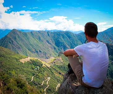
wall. That sector is also known as "Kanturaqay", the name being related to our national flower "kantu". It is constituted by many buildings with "pirka" type walls, that is, made with non-carved mud bonded stones that originally had a clay stucco. Over here there are some "kanchas" (apartments) for non-noble people that must have cultivated the lower terracing; around here there are also some remains of aqueducts and fountains supplying water for people dwelling in the area. From this spot there is a panoramic view of the terracing that seen from the valley's bottom look narrow but staying up here one discovers that they are broad. Its location on the edge of a precipice is also exceptional for watching over and controlling the movement of people or travelers who used the road toward the Paucartambo region and the Antisuyo.
Following the trail toward the west of Qanchisraqay one reaches the crossroads known as " Antachaka" (anta = cooper, chaka = bridge), where there are some water fountains and a surface aqueduct for the terracing. Towards the west, on the irregular almost vertical surface of the mountain there is a large amount of something like hollows: they are looted tombs of the biggest pre-Hispanic cemetery in the region. Today. the cemetery is known as " Tankanamarka" (tankay = to push, marka = spot; it may be translated as "hurling spot"), and according to some estimates it must have contained about 10,000 tombs that were mostly looted. In the Inkan belief it was stated that once persons died they began a newer life; therefore, their mummies were kept along with all their goods and necessary food. When the conquerors arrived they soon knew that inside the Inkan tombs they could also find jewels of precious stones and metals, thus they began with their diabolical profanation and pillaging of ancient Peruvians' tombs. That is why that cemetery in P'isaq contains mostly looted tombs, some mummies are still inside the graves but not their jewels and daily life elements.
Continuing the march, and crossing the wall surrounding named Amarupunku (amaru = snake, punku = gate), which still retains its lintel is the district known as K'alla Q'asa (k'alla = court = q'asa step ) also appointed as Hanan P'isaq (P'isaq Superior), which contains buildings such as "pirka" between apartments, warehouses, tower ladders on the brink of precipices. Following the road after "Amarupunku" there is a small tunnel drilling of 16 mt. (52.5 feet) long and its height is irregular. This was not a main road, but if a secondary that can not be compared to the path of Machu Picchu Inca. Following, the path are many sectors of religious P'isac. Today this sector is appointed as Intiwatana (inti = sun, watana = brooch).
Intiwatana Is the district's most important P'isaq, is the ceremonial center or complex of religious buildings in the city with walls of type "sedimentary", ie that the junction of polished stone has a rectangular outer surface. Their situation at the top of the mountain is extraordinary and visually dominates much of the valley. This sector must be formed of various temples like Qorikancha of Cusco with polls for the various deities. The lack of information makes it difficult to know who surrendered in each temple worship two gods. In the central part of the complex there is a building with a semicircular wall straight lateral and the main gate is to the south, by inference and analogy states that this was the Temple of the Sun in P'isaq.
In the two side walls of his small hands are rising input carved in stone. Through this building there is an altar carved in stone with a conical central bulge is known as
"Intiwatana"
( "Broche of the Sun", but its original name should have been "Saywa" or "Sukhanka") and is due for be used to observe the solar movements with the help of a few other elements or carved angles that served as a "pin" to calculate projections from the shadows.
Today the Intiwatana has many signs, though, it is still possible to see its original form was the altar to carry out various ceremonies to worship the Sun God, to sacrifice animals and also for purposes of divination. Descending the stairs of the Temple of the Sun at the southwest side there is another carving conical that was used with the "Intiwatana. To the west there is an altar carved stone representing the three phases of the Andean religious world: the sky, the earthly world and subsoil. This sculpture may be used as an aid for solar observations.
In this complex there are some other temples with walls of very good quality. His specific duties are unknown, but now the tradition is trying to put their names, without any documentary support. In this area there are also channels and sources remains well carved that due to its quality and status must have strictly religious duties as the water was a particular deity among the Andean people and always had their channels, springs and reservoirs for worship. At about 20 meters (65 feet) in front of the main gate of the complex there is a special font. On both sides of its landfill there are two notches that seem handles; because of its position perhaps served as a bathtub to make "ceremonial baths" as a way to purify the body. In this area there is a partial view of the Urubamba River flowing in a straight line approximately 3.3 km. (2 miles), in Inca times this river was completely focused on P'isaq to Ollantaytambo. The aim of the channel was to win and protect farmland covering a length of about 90 km. (56 miles) in the valley today in many sectors is the remains of the side walls of the channel. Going down the stairs towards the southeast "Intiwatana" P'isaqa this district which has a semicircular shape. It has stone walls, some kind of "pirka", and some others made with absolutely mud. Here is a distribution of "kanchas" (apartments). From the southern end of this sector is possible to see on the surface some abrupt "pukaras" (towers) "qolqas" (warehouses) made of adobe. In this sector, there is a road to go down south to the colonial village of P'isaq which provides an overview interesting to get the parking lot is necessary to take the path of the north.
Traveler Reviews
Certifications

Demonstrating our commitment to quality, we hold ISO 9001:2015 certification, ensuring excellence in our services.

With ISO 14001, we prioritize environmental sustainability, reducing our impact on the planet.

We're honored to be recognized with the Traveler's Choice Award in 2023, a testament to our dedication to exceptional travel experiences.

We are an official agency and tour operator, ensuring a unique and high-quality travel experience to the destinations of your choice in Cusco and Peru.
Recommended by


Travel Associations


